At the end of the 19th century, an astronomer named Percival Lowell first peered up at Mars and observed some dark lines with powerful implications—an extensive network of canals. He was thrilled to see what he considered evidence of an advanced civilization sculpting the Martian landscape as his fellow earthlings were constructing the Suez and Panama Canals.
Despite Lowell’s enthusiasm, these Martian canals were merely an optical illusion caused by the primitive telescopes of the day. But Giovanni Schiaparelli, the scientist who first observed the channels that Lowell interpreted to be canals, mapped out Martian seas and continents as well. Since his time, some studies have supported the idea that Mars had ancient oceans, long since dried up; others have challenged it.
Scientists today are still asking questions about Mars’s watery past. Current evidence strongly suggests that there was once liquid water on the surface, but exact determinations of where, when, and how much still remain. The answers to these questions will give astronomers a greater understanding of Martian atmosphere, landforms, and potential for life.
Now Sholes et al. present a method for analyzing possible shorelines to determine whether they are truly wave-generated ocean rims or other landforms.
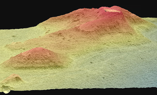
 A 3-D model of proposed ocean shorelines along a crater rim in the northern plains of Mars. The authors used a tool kit to find that they are more likely to be exposed and eroded rock layers. Credit: S. F. Sholes
Most of these potential shorelines were mapped on the basis of low-resolution images from the Viking mission in the late 1970s and early 1980s and other orbital images of similar quality. These lower-quality images made mapping ocean rims like trying to identify a face through a fogged window. Modern, high-resolution images offer the chance to clear the glass, so to speak.
The researchers started with today’s higher-quality images and applied a method that has already been used to identify ancient shorelines on Earth. They combined this method with traditional mapping tools like photogeologic mapping and spectral analysis.
The scientists examined a possible shoreline in a promising three-crater system open to the northern plains, a potential ocean. They found that when examined at high resolution, these shoreline-like landforms broke down and did not match what they would have expected of an ocean shoreline. The geologic patterns were instead more consistent with differences in erosion over layered rock types.
These results don’t necessarily refute the idea of a Martian ocean: It is possible that these landforms represent shorelines that have broken down much more than any we have seen on Earth, but the researchers suggest that it would take extremely compelling evidence to support that kind of claim. Still, their work does not preclude the possibility of other shorelines elsewhere on the planet, and they offer their methods as a way for scientists to reexamine possible shores with updated, high-resolution images, clearing the foggy glass and rooting out the truth about water history on Mars and elsewhere in the solar system. (Journal of Geophysical Research: Planets, https://doi.org/10.1029/2018JE005837, 2019)
—Elizabeth Thompson, Freelance Writer
from Eos https://eos.org/research-spotlights/a-new-way-to-analyze-evidence-of-martian-oceans?utm_source=rss&utm_medium=rss&utm_content=a-new-way-to-analyze-evidence-of-martian-oceans
via IFTTT
