“Can you hear me now?”
Verizon Wireless created its popular television ads from years ago to highlight the commercial value and public interest in wireless voice and data access across the United States. Today, as the number of wireless users across the nation and their appetites for more and faster data continue to grow, government initiatives that wireless service providers support are pushing to open more radio frequencies to commercial wireless services.
The timing could not be worse.
Petitions now in front of the Federal Communications Commission (FCC) urge sharing a portion of the radio-frequency spectrum that is reserved for federal use, particularly for National Oceanic and Atmospheric Administration (NOAA) geostationary satellites. The requests would allow new wireless users into the lowest quarter of the allocated band that spans from 1,675 to 1,695 megahertz (MHz).
Disruptions could decrease the accuracy and precision of weather forecasts and warnings, impeding the work of disaster responders and putting lives at risk.The advanced NOAA satellites, each designed to last 10 years in a mission expected to span most of the next 2 decades, enhance a long-standing method of delivering weather data. The satellites’ wireless broadcasts to receiving antennas include remote surface and flood gauge observations in addition to imagery essential to meteorologists, scientists, and emergency managers. NOAA satellites provide data needed by researchers investigating extreme weather and other natural hazards and retransmit government weather forecasts and bulletins.
Adding new users to the band used by satellites would likely interrupt timely communication of weather and other environmental information essential for effective responses to hazardous and extreme weather, flooding, fires, and other dangers. In other words, such disruptions could decrease the accuracy and precision of weather forecasts and warnings, impeding the work of disaster responders and putting lives at risk.
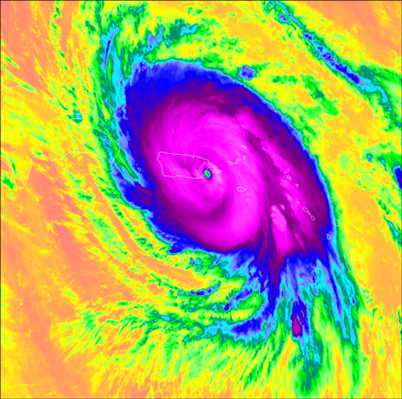
Will We Hobble Our Newest and Best?NOAA recently launched the first two of four satellites in the Geostationary Operational Environmental Satellite–R series (GOES-R), designed to conduct imaging of the Americas into the 2030s. The primary instrument for weather monitoring on these satellites, called the Advanced Baseline Imager (ABI), can image a full hemisphere of the planet every 15 minutes [Schmit et al., 2017] and capture localized imagery up to every 30 seconds for monitoring regional severe weather.
 The GOES-16 weather satellite’s ABI captured Hurricane Maria striking Puerto Rico on 20 September 2017. This infrared image was color enhanced to depict cold cloud top temperatures in blue and magenta and warm ocean surface temperatures in orange. Credit: CIMSS/SSEC
Although the ABI is essential for specialists who produce warnings and forecasts that help protect life and property, it also provides weather imagery for television weather broadcasts and online animations. Such frequent imaging from the ABI is one of the major improvements that the GOES-R series of spacecraft provides compared with previous satellites.
GOES-R satellites also deploy space weather instruments, a lightning mapper, and a host of communications channels that retrieve and disseminate ground and satellite observations.
For the data that GOES-R satellites collect to reach operational meteorologists, scientists, and emergency managers, the spacecraft communicate on four channels at central frequencies from 1,679.9 to 1,694.1 MHz. These channels provide data at tremendous reliability to the users who depend on them.
However, this reliability hinges on the current spectrum environment in which there are few other users to create sources of interference that can disrupt the faint satellite signal. The signal strength from satellites thousands of kilometers away is much less than from cellular phones and towers. Listening for a satellite signal amid a network of cell phones and towers at a similar frequency would be akin to listening for a whisper in a crowded sports arena.
Advanced Weather and Hazard Monitoring at RiskShould the FCC make 1,675–1,680 MHz, the lowest fourth of the allocated spectrum for GOES-R satellites, available to commercial wireless services, two of the four GOES-R communication channels would be most at risk because their central frequencies are closest to the proposed range for sharing.
One of them, called the Data Collection Platform Relay (DCPR), transmits at around 1,679.9 MHz. Among other uses, DCPR transmits reports from river gauges and other remote ground observation platforms whose timely receipt is crucial to flood and weather forecasting. During Hurricane Irma, for instance, the Florida Department of Transportation used such gauge readings to decide whether to close highways that served as evacuation routes. In the West, instruments near remote wildfires use DCPR to share local conditions, providing information that is essential for ensuring the safety of communities and firefighters.
GOES-R and other satellites provide the only method to monitor much of the weather over the oceans as well as conditions above many of the world’s volcanoes.The other channel at greatest risk, known as the GOES-R Rebroadcast service (GRB) and operating at around 1,686.6 MHz, beams satellite imagery to operational and research meteorologists in academia, government, and industry at a data rate of around 31 megabits per second, slightly faster than most fourth-generation long-term evolution (4G LTE) cell service. Mainly because of ABI’s rapid and continual imaging, GRB data continuously flow from the satellite to antennas on Earth. Because the timeliness of weather information is of utmost importance for public safety, the service-level agreement for GRB uptime is 99.988%, allowing only 5 minutes of downtime every month.
GOES-R and other satellites provide the only method to monitor much of the weather over the oceans as well as conditions above many of the world’s volcanoes [Pavolonis et al., 2006], including those along critical air routes between North America and Asia. The safety of airline passengers flying between the United States and Asia depends on the uninterrupted receipt of volcanic eruption and ash information derived from images transmitted via GRB.
Also in Harm’s Way?The remaining two GOES-R communications channels, the High Rate Information Transmission (HRIT) and the Emergency Managers Weather Information Network (EMWIN), both at around 1,694.1 MHz, might also experience interference from new transmissions above 1,695 MHz. HRIT sends lower-resolution and less frequent satellite imagery data to users who cannot handle the more substantial stream of imagery from GRB. EMWIN provides weather forecasts and warnings from the NOAA National Weather Service to emergency managers in near real time. Users of HRIT or EMWIN include the U.S. Department of Defense and other federal agencies, as well as state and local officials and emergency managers.
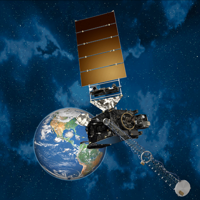
Vulnerabilities: Interference and Cloud Failure The first weather satellite in the GOES-R series, now designated GOES-16, observes Earth from geostationary orbit in this artist’s rendering. The satellite became fully operational last December. Credit: NOAA/Lockheed Martin
If there were interference with the satellite signal, receiving antennas would not capture the data, and the transmission would be irrecoverable, much like disruptions to over-the-air high-definition television. The weather community has experienced the effects of interference before, with the GOES-N, O, P generation of geostationary satellites that preceded the GOES-R satellites. In 2015, interference temporarily obscured the view of a tropical cyclone over the Pacific Ocean. Although this interference was momentary, it illustrates the potential for irreversible harm to the weather monitoring and natural hazards alerting process that the American public has come to rely on.
Petitioners in favor of sharing have recommended the creation of an Internet-based cloud service as a suitable alternative to satellite transmissions of the data. This service is not achievable, even with the best enterprise-grade terrestrial Internet services available today. Moreover, when disaster strikes, it is often the power and communications infrastructure that is the first to fail, rendering a potential cloud service inaccessible. In contrast, satellite transmissions remain robust unless the receiving dish is destroyed.
Penny-Wise, Pound-FoolishUnfortunately, disasters are becoming more frequent and, in recent years, increasingly expensive. The cost of weather disasters in the United States hit record highs in 2017, exceeding $230 billion according to the NOAA National Centers for Environmental Information (NCEI). Those tremendous losses resulted largely from three strong, land-falling hurricanes that the first GOES-R satellite, GOES-16, helped meteorologists track. After Hurricane Maria destroyed the weather radar in Puerto Rico, GOES-16 was the primary asset to support weather monitoring for the island in the months that followed.
Weather disaster costs may increase in future years. New research has found that the speed of hurricanes is decreasing [Kossin, 2018], which will inevitably increase the severity and extent of flooding from associated heavy rains. In addition, a recent NCEI study found that frequencies of high-tide flooding along Gulf of Mexico and eastern states’ coastlines are increasing at an accelerating rate [Sweet et al., 2018].
The combination of slow-moving hurricanes and more frequent high tides could prove recurrently disastrous in the coming decades. We will need the imagery from GOES-R satellites during and after these disasters to monitor and better adapt to this trend.
We must preserve the clear airwaves for reliable satellite relays of weather and other environmental information.Although the revenue from selling spectrum currently reserved for government use entices lawmakers looking to balance the federal budget without raising taxes, it is a minuscule fraction of just 1 year’s disaster losses. The FCC estimates that sharing 1,675 to 1,680 MHz could result in revenues of $60 million a year, but only for a decade [Federal Communications Commission, 2017]. That 10 years of revenue would amount to only 0.26% of the $230 billion estimated by NCEI as the lower limit of weather disaster costs for 2017 alone.
In contrast to the relatively small revenue the U.S. government could realize from a 1,675–1,680 MHz spectrum auction, the nation will have spent around $11 billion on the GOES-R program by 2036 to ensure that Americans are aware of adverse weather for the next 2 decades. With that cost comes an expected return on investment: that adequate research and Earth monitoring will be conducted using GOES data to understand natural hazards facing the world today and in the future. Much of that will be lost if airways are jammed and scientists can’t hear the signals from the state-of-the art satellites overhead.
We must preserve the clear airwaves for reliable satellite relays of weather and other environmental information. Those uninterrupted signals will help meteorologists and emergency managers continue to provide advanced warning and effective, lifesaving responses to protect the American people, their property, and the country’s commerce.
Tell Your StoryInterested parties, particularly regular consumers of weather satellite information, can file a comment with the FCC in proceeding RM-11681 at the FCC’s Electronic Comment Filing System.
The post Wireless Frequency Sharing May Impede Weather Satellite Signals appeared first on Eos.
from Eos https://eos.org/opinions/wireless-frequency-sharing-may-impede-weather-satellite-signals?utm_source=rss&utm_medium=rss&utm_content=wireless-frequency-sharing-may-impede-weather-satellite-signals
via IFTTT

